Understanding lake maps, the terminology used, seasonal patterns of bass and how that relates to areas on the map, and good places to start fishing on a new lake is very important to any fishing trip. It's also important for safety reasons.
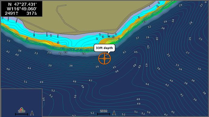
We'll start by breaking down the different parts of the map that enable you to have a picture of the underwater world. First, most maps are color coded to give you a visual effect as to what areas are the deepest, maybe at the dam, down to the shallowest areas on the upper end. The colors generally are in shades of blue with the deepest part of the lake being the darkest. Some maps will also show areas of timber or stumps with boat paths indicated.
The contour lines are the most important part of the map. These breaklines show stages of depth from the shore out to the main creek channel, which typically is the deepest part of the lake no matter what part of the lake you are viewing at the time. The closer the contour lines are together the faster the drop-off; the wider apart the contour lines, the slower or flatter the fall of the lake bottom. These lines show you how far points come out into the main lake or cove, where humps or ridges are in the main lake and define the main and secondary creek channels. The contour lines are usually indicated in feet, at intervals of 5 to 10 feet apart. Some maps will have elevation numbers.
Along with the contour lines you can see where old roads cross the main lake and coves. Where the roadbed crosses the main or secondary creeks, there will usually be a bridge or the remains of a bridge. Any other underwater structures will also be indicated such as houses, old railroad tracks, wells, levees, tank dams and cemeteries. The maps will also show the distance from the dams in miles as you go up the lake. Some maps will even show channel markers to give you the best path down the lake.
Maps will have a direction marker giving a North indicator that you can use as a reference to help pinpoint your location if you have a compass, or know which way is north.
So now let's talk about how you use the information on the map to help your fishing.
In the spring, bass make the biggest movement of the year from their deep-water winter areas in stages to the shallower coves and flats to spawn. This may take a month or so to happen and the bass will move up to a mid-range area first, typically 10 to 15 feet. As the weather changes the bass will move up to shallow water to spawn and back out if the temperature drops, until the spawn is complete. After the spawn, bass move back and forth between the mid-range depths (10 to 15 feet) to shallower water as they feed. As the summer months begin, they move back out to deeper, cooler areas of the lake along roadbeds, humps, levees, tank dams and creek channels. They will also school around creek channels in main lake coves during the summer. In the fall as the water cools, the bass will move back up to the shallows and feed on shad before winter comes. Usually, in the fall, the lake will turn over (warm water from the bottom of the lake rises to the top, while cooler water on top falls to the bottom) and the fishing is poor during this period. When the water cools and the winter months arrive, bass move back to deeper water and are less active. Bass use the contour lines or breaklines and creek channels as paths or highways to move from the deeper areas to the shallower flats and coves.
Knowing all of this, you can look at areas where the primary or secondary creeks come in close to points or shorelines to give you an idea of the best places to start fishing. Bass will use these contour lines or breaklines along with brush piles, stumps, laydowns, rock piles and grass lines to move around the areas of the lake where they live. One of the best spots to look for bass on a lake is an area where there is deep water near a dock or grass line, close to shore. This gives bass the best of both worlds to live in because they can move up and down with ease as the light or weather changes without going very far. These bass are less affected by the changes because they have less distance to move with very little effort.
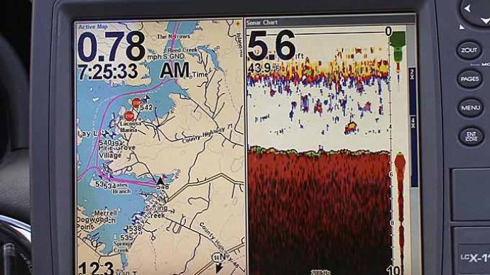
On new lakes, the best places to start are main-lake points and then to secondary points. The points that come near creek channels would be the best areas to try first. The next areas that would be good are roadbeds, especially if they have a good rise from the bottom of three to six feet with stumps or brush piles on the sides. A roadbed running across a cove will give you a range of depths from the shallow shore down to the creek area where the old bridge crosses the creek. Most of these areas can be found on your map. If you have good electronics, you can enhance the picture of the underwater world, so you can spend the most productive time fishing in the most productive places.
Writing about how to read a map is somewhat like trying to describe a painting. I hope I have painted a clear picture that will help you understand how to read a map effectively and find some great bass catching spots on your favorite lake.


