Shallow water — 10 or fewer feet — is where most bass anglers feel at home, whether flipping jigs to brush and docks, twitching jerkbaits along riprap, or skittering hollow-bodied frogs across matted aquatic vegetation. And for the most part, while wearing a good pair of polarized sunglasses, they only need to peer over their boat’s gunnel to see where and what to fish. But as convenient as that is, they’re not always seeing the whole picture.
Distance, depth, cover, and clarity determine how deep into the water you can see. And while history, plenty of casts, or a good guess might uncover what’s under the surface, fishing electronics tell you precisely what’s there.
Major League Fishing angler Mark Daniels Jr. is no stranger to fishing with electronics. He stared at his for four days during the 2018 Bassmaster Elite Series event on South Dakota’s Lake Oahe, where he weighed 20 smallmouth for 69 pounds and 9 ounces, enough to win. While those bass were between 15 and 20 feet deep, he finds his electronics helpful when fishing shallower. “You can always use your electronics,” he said. “I always have my eyes peeled.”
Mapping
One of the first things Daniels looks at when fishing shallow water is his electronics’ mapping function. It’s essential to read and understand the map’s contour lines. The distance between them can reveal stretches of deeper water or expanses of shallow water. When contour lines are far apart, the latter is especially important during the spring, when bass are searching for spots to spawn.
Major League Fishing angler Ish Monroe found slightly deeper water pay in 2012 when he won the Bassmaster Elite Series tournament on Lake Okeechobee with 20 largemouth that weighed 108 pounds and 5 ounces. He used the contour maps on his electronics to find and fish ditches a couple to 30 feet wide. While the bigger largemouth knew they would take them in and out of spawning flats, you’d never know they were there by simply looking out over the water.

Finding these spots requires a high level of accuracy. For example, maps with contour lines at 5-foot intervals show the small drops that shallow-water bass crave. So, look for mapping that draws contours at small intervals such as 1 foot. It doesn’t take much depth difference to hold shallow water largemouth. Even 12 inches can mean a lot to bass looking to escape a summer cold front.
Traditional sonar and down scan
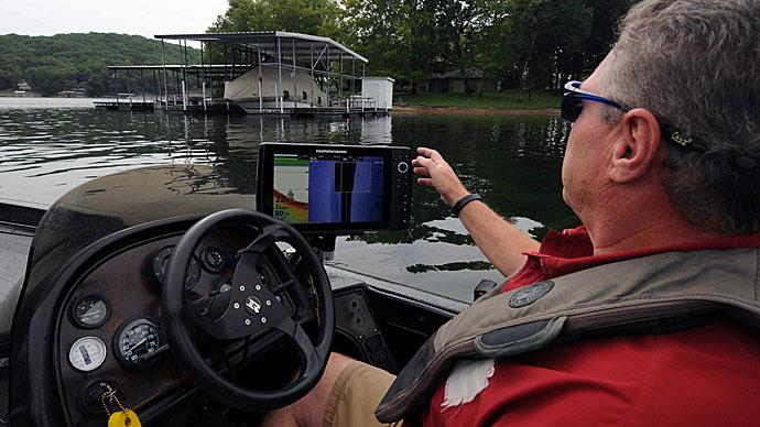
What fish finders do best — showing you what’s underneath your boat — may not be their strongest feature in shallow water. But Bassmaster Elite Series angler Jason Williamson said there’s still important information that can be gleaned from traditional sonar and down scan.
Williamson uses his electronics up until he almost reaches the bank. “They’ve gotten so good,” he said. “We found an underwater car in 12 feet of water, and you could see the trim around the windows. You could see everything. You have to get shallower than 3 or 5 feet before you notice any clutter [on the screen].” Before that point, his outboard kicks up too much sediment for the transducer to get a precise reading. So, he jumps on his trolling motor and uses the electronics mounted on the bow of his boat. It’s a stealthier approach that provides a clearer view.
Switching propulsion devices isn’t the only adjustment you should make. Williamson said turning down your unit's sensitivity will also lead to clearer pictures in shallow water.
Look for slight changes in the bottom, such as a small drop that could indicate a creek channel or ledge used by traveling and feeding bass. Stay alert for color changes in the bottom return, which indicate the hard bottom is turning soft or vice versa. You may see a log or scattered brush, just enough cover to hold a bass. Even small clues can help you solve that day’s fishing puzzle.
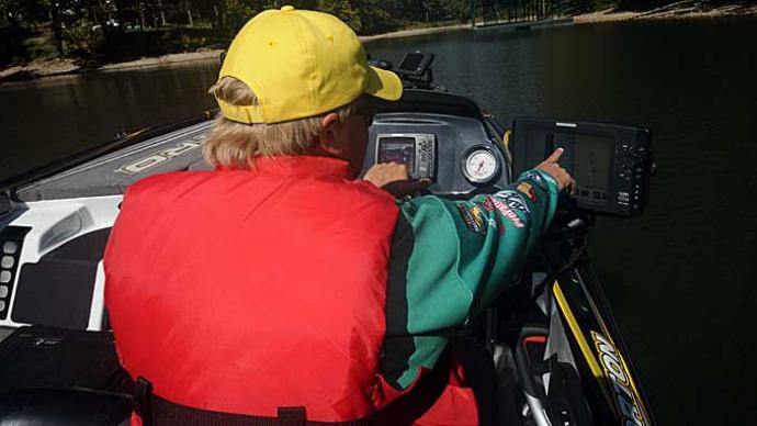
Forward and side imaging
While there’s less to see while looking down as you fish shallower, there’s still plenty to see around your boat. And that’s something fish finders continue to do better.
Williamson uses the side-scan function on his Lowrance units while idling across shallow flats and points, looking for submerged cover and structure that other anglers are missing. It might be a clump of aquatic vegetation loaded with prespawn largemouth, a brush pile spotted bass are using to attack baitfish, or a small rock pile covered with big smallmouth. He even peaks under docks for sunken brush and bass.
Side-scan will reveal shallow-water structure, too. Williamson said it will show where a road bed, for example, heads after it leaves the bank and before it meanders into the depths. These spots are so shallow that they are ruined by running over them with your outboard. Side-scan allows you to stay back, even remotely placing a waypoint over the cover so you can return later and sneak up with your trolling motor.

Daniels enjoys a similar horizontal view and the option of looking straight ahead. His bow-mounted electronics are equipped with Garmin’s Panoptix transducer. It provides a real-time view of what’s happening, allowing him to follow the bass as they move and react to his lure.
The Panoptix transducer attaches to a trolling motor so that Daniels can aim it in any direction. “It’ll work in 2 to 3 feet of water,” he said. That allows him to find submerged brush, for example, from 50 to 70 feet away, long before he rolls up on it.
Hydrowave
Fishing electronics aren’t limited to graphs. In today’s wired world, they include various devices, each adding more information or completing a task that contributes to catching more and bigger bass.
Williamson mounts a Hydrowave to the bow of his Nitro bass boat. He uses its sounds, such as baitfish movements recorded in the wild, to convince the bass that he’s fishing for that it’s time to eat. Its assistance firing up deep schools of bass is well established, but he says it’s as effective in shallow water, with a minor adjustment.
After arriving at a shallow-water spot, Williamson turns on his Hydrowave and lowers its volume. While he’ll run it at maximum volume in deep water to ensure its signal reaches the bass, there’s less water to cover in these spots. But even in a quieter setting, he believes it makes a difference, especially while throwing baitfish imitating lures — spinnerbaits, square-bill crankbaits, jerkbaits — around shoreline cover.
Tablets and smartphones
The definition of fishing electronics is widening in other ways. It’s no longer restricted to devices mounted to a bass boat, kayak, or kick boat. Now they can be found on your desk at home or even in your pocket.
Most of today’s fish finders will interface with a home computer, which can download waypoints and tracks for safe keeping and upload maps and satellite photos from websites such as Google Earth. The latter provides a fresh perspective on a body of water, revealing a wealth of information.
Williamson studies Google Earth photos as part of his pre-tournament preparations, especially if he’s never fished the venue. He said it’s time well spent for coastal fisheries such as Winyah Bay in South Carolina or Sabine River, which separates Texas and Louisiana. Most are massive, offering anglers the option of running many miles in several directions. But when you commit to one, he said, the rest become unreachable during that day. And with limited practice time, knowing what each offers helps determine the best starting point.
Google Earth photos are taken periodically, allowing you to look back and compare how each body of water has changed through the years. Williamson said you can find out how each is affected, for example, by drought and rain, simply by scrolling through the versions. Match the expected tournament conditions to similar ones in the past, he said, and you have a pretty good idea of how things will look when you arrive, including, for example, which areas are most likely to turn muddy from the rain.
With a bit of work at home, you can place waypoints on Google Earth and then transfer them to your unit in the boat, giving you a ready-made milk run of spots you want to explore. And if you’re fishing where there’s enough signal, you can pull up satellite photos on your smartphone or tablet to give you a look while on the water.
Smartphones can provide more information, including tide times, fishing reports, weather forecasts, and nautical maps. All are important whether you are fishing shallow or deep. Bookmark that information before you head out, so it’s easy to find. While some of that information can be found on certain fish finders, accessing it on your smartphone can save screen space for other information or better views.